New Study Shows Tornadoes Tend Toward Higher Elevations and Cause Greater Damage Moving Uphill
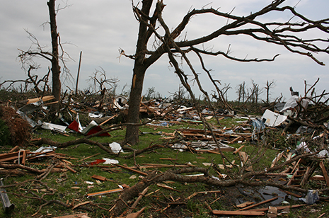
The most severe damage caused by the EF5 tornado that struck Joplin, Mo., on May 22, 2011, occurred on flat terrain or when the tornado was moving uphill.
FAYETTEVILLE, Ark. – The first field investigations of the effect of terrain elevation changes on tornado path, vortex, strength and damage have yielded valuable information that could help prevent the loss of human life and damage to property in future tornadoes.
Engineering researchers at the University of Arkansas analyzed Google Earth images of the massive 2011 Tuscaloosa, Ala., and Joplin, Mo., tornadoes and found similarities between the two in behavior and interaction with the terrain. The findings likely apply to all tornadoes.
“We wanted to understand the impact of terrain on damage magnitude and tornado path,” said Panneer Selvam, professor of civil engineering. “Information about this interaction is critical. It influences decisions about where and how to build, what kind of structure should work at a given site.”
The researchers’ analysis led to three major observations about the nature and behavior of tornadoes as they interact with terrain:
- Tornadoes cause greater damage when they travel uphill and less damage as they move downhill.
- Whenever possible, tornadoes tend to climb toward higher elevations rather than going downhill.
- When a region is surrounded by hills, tornadoes skip or hop over valleys beneath and between these hills, and damage is noticed only on the top of the hills.
For years Selvam has studied the effect of high winds on structures and developed detailed computer models of tornadoes. He and civil engineering graduate student Nawfal Ahmed used tornado path coordinates from the National Oceanic and Atmospheric Administration and imposed this data on overlaid Google Earth images. They studied the tornadoes’ damage in depth by comparing historical images to aerial photographs taken after the events. Google Earth photographed Tuscaloosa one day after the tornado there. For the Joplin tornado, an aerial photograph was taken on June 7, 16 days after the twister.
In terms of magnitude of damage, the data clearly showed that tornadoes cause greater damage going uphill and huge damage on high ground or ridges. Damage decreased as the tornadoes moved beyond the crest of a hill and going downhill. While it seems logical, this data contradicted a finding from a previous study in which Selvam and a different student found that a hill can act as a protection wall for buildings.
The researchers also found that when approaching a geographic intersection, tornadoes climb toward ridges rather than go downhill, which is counterintuitive when one thinks about wind or water seeking the path of least resistance. With both the Joplin and Tuscaloosa tornadoes, there were several locations where the paths changed direction. At each of these locations, or intersections, the tornadoes consistently sought higher ground.
Finally, Selvam and Ahmed discovered that when a region is surrounded by hills, tornadoes tend to maintain a consistent trajectory rather than follow topographical contours. jumping over valleys to hit hilltops and ridges. With both tornadoes, Selvam said, it was clear that all highland areas suffered the most damage.
Occurring less than a month apart, the Tuscaloosa (April 27) and Joplin (May 22) tornadoes are two of the most deadly and expensive natural disasters in recent U.S. history. Tuscaloosa was an EF4, multiple-vortex tornado that destroyed parts of Tuscaloosa and Birmingham, Ala. The tornado killed 64 people and caused roughly $2.2 billion in property damage, which, at the time, made it the costliest single tornado in U.S. history. Only a month later, the Joplin tornado, an EF5 with multiple vortices, which damaged or destroyed roughly a third of the city, killed 158 people, injured 1,150 others and caused $2.8 billion in damage.
The researchers presented their findings at the 12tth Americas Conference on Wind Engineering.
Selvam is holder of the James T. Womble Professorship in Computational Mechanics and Nanotechnology Modeling. He directs the university’s Computational Mechanics Laboratory.
Contacts
Panneer Selvam, professor, civil engineering
College of Engineering
479-575-5356,
rps@uark.edu
Matt McGowan, science and research communications officer
University Relations
479-575-4246,
dmcgowa@uark.edu
Headlines

Four Students Named Goldwater Scholars; Two Earn Udall Honorable Mentions
Four U of A students have received the prestigious Goldwater Scholarship, an award for top students in mathematics, science, and engineering.

Cross-Campus Collaboration Culminates in New Outdoor Geological Installation
Grand opening event to celebrate the new GeoLab installation at the U of A’s Gearhart Hall courtyard is set for May 3. The installation will be open to the public year-round.

First Students to Use Online Degree to Hone Nursing Leadership, Elevate Patient Care
Hanna Baxendale and Wendi Kimbrell will begin coursework in the Doctor of Nursing Practice-Executive Master of Business Administration program offered by the Eleanor Mann School of Nursing and Walton College.

Join the Office for Sustainability on a Final Cruise to Campus
Cruise to Campus Wednesdays have fostered a gathering space for individuals interested in biking to campus. Drop by the Old Main Lawn from 7:30-10 a.m. Wednesday for coffee, something to eat and conversation.

Fay Jones School Student Ambassador Program Gives Voice to Design Students
The student ambassador program at the Fay Jones School of Architecture and Design is built to connect top design students with their school, its alumni, its future students and others inside and outside the school.